Quantcast
Channel: GPS Power Forum: tech support and help desk
Viewing all 17836 articles
Browse latest View live

ANDROID Alpina Serra de Tramuntana, Mallorca, Spain

$
0
0
MALLORCA.SERRATRAMUNTANAalpinadigital

Editorial Alpina digital maps, in an exclusive format of COMPE GPS / Oruxmaps. Provides raster maps of the Sóller area in 1:15,000 scale, Sierra de Tramuntana, Mallorca in 1:25,000 scale, and Mallorca Senderista in 1:50,000 scale.

Includes:
MALLORCA_50K.RMAP (1:50,000)
http://www112.zippyshare.com/v/1Fitdrt4/file.html
Sóller_2013.RMAP (1:15,000)
http://www112.zippyshare.com/v/xkpzctAp/file.html
Tramuntana Central_2013.RMAP (1:25,000)
http://www112.zippyshare.com/v/jMTbpuOE/file.html
Tramuntana Sud_2010.RMAP (1:25,000)
http://www112.zippyshare.com/v/FKuLMFvf/file.html
Tramuntana_Nord_2013.RMAP (1:25,000)
http://www112.zippyshare.com/v/UtoZJf7b/file.html

WIN CE WinCE iGO Nextgen_9.19.5.578126 Kajoe Pongo S100 28-02-2016

$
0
0
Hi dear navigators;

Finaly after days of hard work is here my WinCE version of Pongo. It is probably my last post. I had posted more items and I saw a lot of views. But only a few comments. This means probably that the versions I
Posted worked good. But only grabbing and no comments is not positive for the hard work.

But for know have fun with this new WinCE version. Translating English to Dutch language was a terrible job. Not all Language could be changed, because some English words are
Fixed in a picture. I have tested this version extensively. And for me this is for now the best version with lot of settings, Like transparancy, Colors or no Colors, etc.

With:
All languages
A lot of Voices
TTS Voices as far as I could find them
Licenses
latest Global CFG
Diricons can all set in different Colors (Black, White, Orange, Kia-red, Red, Blue, Green.
Transparancy can be set to backgrounds, Buttons and Streets. See the pictures.
Branding big and nice file
A lot of settings and Extra settings
For Dutch people: All the language is translated from English to Dutch by me. If you see something wrong, or to improve language. Please let me know.
Etc. etc. etc.

Do not use your old files. Use this complete folder with sys.txt. Otherwise you could have problems or errors during installation or errors while using it. During testing I had no errors at all and Witson S100 device worked smooth and quickly. Recalculating was very quick.

Have fun with it.

Kajoe

Thanks to Texas, catymag, frontzosd and offcourse Pongo, and all others who worked hard on skinning.

Quote:

"Attention!
Only for non-commercial use!"
Credits and courtesy 4pda.
Spoiler: source Show

Spoiler: screen1
241ktp1

Spoiler: screen2
2mwxa54

Spoiler: screen3
2ni4il3

Spoiler: screen4
2u9hnpy

Spoiler: screen5
15hmkhc

Spoiler: screen6
aotlee

Spoiler: screen7
15nwwu8

Spoiler: screen8
ibe25g

Spoiler: screen9
sqp6i8


tidy up

$
0
0
Sorry, I know it's still incomplete. But there is no New Jersey? It seems it was skipped.

Thanks.

TurboWin 8.0.2

$
0
0
hi people I´m bringing you today TurboWin 8.0.2, it cames without charts and with A.I.S. function, you only need to paste the folder into Program Files folder or wherever you want
I hope that this could be usefull ;)
best regards


if someone need charts I can upload it anytime later

partial update rt4 8.31

$
0
0
407 coupe, rt4...I update on 8.31 version.
after update; "CLIMA" button/screen dont work/apear, and there is no "video" option in menu...
all other works ok..
Please any hint..
Also on start up there is on screen warning about emergency calls (bat it goes away with ECS)

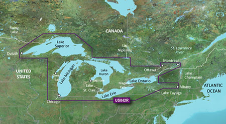
BlueChart g2 Vision VUS042R - Great Lakes v2015.5 (17.00)

$
0
0
BlueChart g2 Vision VUS042R - Great Lakes v2015.5 (17.00)

Detailed coverage of all the Great Lakes, Green Bay, Saginaw Bay, Georgian Bay, Lac Nipissing, Lake St. Clair, Lake Simcoe, Seneca Lake, Cayuga Lake, Oneida Lake, Trent-Severn Waterway, Thousand Islands, the St. Lawrence River from Kingston to Montreal, the Ottawa River from the St. Lawrence River to Ottawa, Mohawk River, Rideau River, Welland Canal and Erie Canal.

FID 3846, PID 1, region 19,13

Download:
Quote:

Locked: Download
status 7ZGTJl7E

UnLocked: Download
status Sm9SqFrZ

2pjj3ve4
Code:

https://buy.garmin.com/en-US/US/prod512936.html

Maps for a A4

$
0
0
Hello all,

I have a Audi A4 from 2006. I try lots of maps from 2015 and 2016 but no one works.

In the car documentation says:

Audo A4 2.0 TDI
8E/LBREF1-FM6

Witch maps could I download?

I really appreciate your help.

Best regards.

TomTom Android 1.4 APK + Greece Map 965.7250 + SpeedCams Included

$
0
0
TomTom Android 1.4 APK + Greece Map 965.7250 + SpeedCams Included


tomtom android


TomTom Android 1.4 APK + Greece Map 965.7250 + SpeedCams Included |Size 286 MB
Last minute plans? With the TomTom Navigation app, driving somewhere new couldn’t be easier. You’ve always got your smartphone with you, so navigation’s close at hand. And losing your signal is not a problem, because the app works without it. You’ll have constant access to the same maps, technology, and world-class navigation as on our GPS devices. It’s the app that drivers can rely on.

*** Great reasons to choose TomTom Navigation ***
Only the TomTom Navigation app offers all this:
- The most accurate TomTom maps in your pocket – no mobile signal needed
- FREE Lifetime Maps. Always drive with the latest map and get to your destination faster. Download 4 or more full updates every year for the life of your app.
- Reliable arrival times at all times of day with IQ Routes
- The quickest routes through traffic. Powered by TomTom HD Traffic (1)
- Fewer speeding fines with real-time camera alerts via TomTom Speed Cameras (1)
- Advanced lane guidance for extra clarity when navigating difficult junctions
- Spoken street names, helping you keep your eyes on the road. (2)

*** OTHER FEATURES ***
- 2D/3D driving view
- Clear voice instructions
- Fast route recalculation
- Multi-stop routes
- Eco Routes
- Navigate to contacts
- Search TomTom Places and POIs
- Automatic music fading
- Automatic day & night mode
- Car symbols
- Map colors

*** BEFORE YOU BUY THIS APP ***
1. Check that you have at least 591Mb of free storage space, either on your internal phone memory or external storage. To look it up, go to your phone settings, and then data storage.
2. If there’s enough storage, buy the app using your Google account and install it on your phone. You now need to download the latest TomTom map before you can use the app.
3. Connect your phone via Wifi to the internet and open up the app. You will then be able to download your new map. This download may take up to two hours depending on your internet connection. Connect your phone to a charger and stay in range of your WiFi network until the download is complete.
*** MORE INFORMATION ***
(1) Check
Code:

http://android.tomtom.com
for availability per country. Services are available via in-app purchase and require a mobile phone connection. Your operator may charge you for the data used and costs may be significantly higher when used abroad. Services can only be used on one device at the same time. If you want to use your subscription on a different device, login with your MyTomTom account in the TomTom Shop on your preferred device.
(2) Spoken street names comes in the following languages: Portuguese, Spanish, British English


Screenshot 2016 02 28 22 24 55


Instructions

1. Download all parts of your area.
2. Unpack anywhere.
3. Copy folder "tomtom" to your SD card.
4. Copy included .apk to your SD card.
5. Disable any internet connection in your phone (Put it into Airplane Mode)
6. Install the .apk
7. Launch the program. Let it load all it needs. Then close program.
8. Enable internet connection.
9. Enjoy!


Credits : @modemakias


Password


Code:

download


Garmin Azerbaijan Map 2015 V01

$
0
0
Garmin Azerbaijan Map 2015 V01


Karta


New routed map of Baku and Azerbaijan for GPS Garmin and Garmin under license, has user-friendly interface, "night" and "day" modes, great detail and many addresses and facilities such as schools, Universities, post offices and public Agencies, petrol stations, shops, restaurants, hotels, more, net of all roads and streets in the localities. Garmin Navigator will help build the shortest route, taking into account the traffic avoiding violations of TRAFFIC RULES. At each release detailing cities with address search is expanding.

Code:

http://www.garmin.az/azmap.html
Code:

/gmapsupp.img, length 16775168
Header:          01.06.2015 16:45:23, DSKIMG, XOR 00, V 0.00, Ms 0, 000-00000-00
Mapset:          Azerbaijan_Map_2015_V01
fat:                1000h - 1200h - 7000h, block 2048
maps:                6, sub-files 17

Sub-file        fat    length
 00001352 MD2  1200h      9263
        date 23.07.2015 16:24:13
        000-00000-00
 00001352 MDR  1400h  1092338
 00001352 SRT  1A00h      968
 I0000548 TYP  1C00h      331
        date 19.05.2015 13:14:55, CP 1252, PID 1, FID 1352
 I08AA000 DEM  1E00h      233
        DEM layers: 3, N: 42.187460, W: 49.218703
 I08AA000 LBL  2000h    632293
        CP 1252, Western European
 I08AA000 NET  2400h  1266884
 I08AA000 NOD  2A00h  2278490
 I08AA000 RGN  3400h  1563372
 I08AA000 TRE  3C00h    39896
        map 8aa000 (9084928)
        PID 1, FID 1352, region 1,1
        date 19.05.2015 12:30:58
        priority 24, parameters 1 4 23 1, locked, signed
        N: 41.062860, S: 39.553528, W: 49.321146, E: 51.266241
        Custom MPC Map
        Copyright 1995-2015 by GARMIN Corporation.

download:


Spoiler: credits
to a friend who sent me this and Moldova map. Big thank you!

Nüvi 2495 Keyboard files

$
0
0
Hello.
How to restore .kbd (keybord) files? I can't find corresponding thread.
Thank you.

ANDROID Need help adjusting icon size for Gird Menu

$
0
0
Hi all skin experts,

First of all, I'm not using Pongo skin or anything, just the default. I added grid_menu_layout.zip into two different versions of iGo NexGen. Here is what I see

In iGo NextGen 9.19.1.484935, it looks normal, especially 3 buttons (icons) inside the bottom box.

Screenshot-1.jpg

In iGO NextGen Avic 9 18 28 624772, the icons in the bottom box appear too small. It's almost impossible to select any of them (especially while you're driving). By the way, I tried to look them up in *.ini, *.css, *.ui, but not sure what they are called. Is that Quick Bar?

Screenshot-2.jpg

Back to Grid menu, in iGo NextGen 9.19.1.484935, it looks good.

Screenshot-3.jpg

In iGO NextGen Avic 9 18 28 624772, however, the size of each button is too big. As you can see from the selected area in the picture, it's bigger than the border of the 'box'.

Screenshot-4.jpg

Can anyone shed some light on how to fix this? Again, the grid_menu_layout.zip is identical in both tests. There are no "skin" package from other places. Only the default ux folder is in each version of NextGen.
Attached Images

ANDROID iGO Primo - TMC is a bit strange!

$
0
0
Hi Gents,

I'm testing iGO Primo right now - it sure looks good :-)

I have a small issue with traffic information - it seems like being (very) delayed!

Driving home from work today on my first ride with iGO I was impressed - but TMC was strange.
I did get messages about "Stau" - but it was around 300 meters before the traffic died!

This is from my sys.txt - does this look OK?

[tmc.src.http]
enabled=1

[traffic.settings]
traffic_enabled=1

[tmc-http]
enabled=1
servers.size=1
servers[0].url="http://htmc.naviextras.com/nng-igo-tmc-primo/0/"
servers[0].url="http://zippy.naviextras.com/services/tmclite/data/5/0/"
servers[1].url="http://zippy.naviextras.com/services/tmclite/data/5/2/"

Cheers and thanks in advance

ANDROID Speed camera radar (PRO) v1.62

$
0
0
Speed camera radar (PRO) v1.62
Requirements: 4.0 and up
Overview: ★★★ This application does not contains any advertisements! ★★★

y1LYLyVrRzMpcdSkx4MZrZ5Uf7Sx9q5t4vz7MZqompAbqD9qLzwfHURt7Uyo4SnvrUis=h900

★★★ This application does not contains any advertisements! ★★★

This application is used to detect hazards on the road, such as speed cameras (mobile ambush, static speed cameras, red light cameras), speed bumps, bad roads and etc.
This application uses database of hazards previously detected by other users.

Before you buy, you can first try the free version.
Each user can develop a database of hazards for his country.

Please note, that the application does not scan radiation police radar in real time for the application is used only database hazards identified earlier by users.

Any user can add new hazard to shared database. Also user can influence on rating of hazard (when user get danger alert he can define whether danger exists or not in fact).

The application plays the sound and shows hazard on the map and distance to this hazard.

If you are connected to the internet you will be able to monitor the traffic jams.
There is a feature update the database of the hazards.

The application may run in the background (even when the screen is off), just enable option "Use speech when hazard detected".

★★★ Features ★★★

★ Night mode adjustment on screen
★ 3D tilt on map support (3D buildings)
★ Map auto zoom and rotation map along the way
★ Dashboard with current speed
★ 140 000 active hazards POIs around the world (check your country in FREE version of this APP at first)
★ Daily database updates!
★ Support voice alerts
★ Support of working in background or with other Navigation APPs
★ You can add their own POI to shared database

New

v.1.62
1. Crash fix on Android ICE CREAM SANDWICH (API 14 and 15)
2. You call "ADD NEW POI" functionality using multi gesture (double tap using 3 finger)
v.1.61
1. Small changes in design
2. Promo codes functionality
3. Possible to add new direction type during new POI adding
v.1.60
1. Ability to disable function in settings "Draw notification over other apps when app is started"
2. Notification about connected bluetooth handset in voice setting
3. Bug fixing

This app has no advertisements

More Info:
Code:

https://play.google.com/store/apps/details?id=com.lelic.speedcam.paid&hl=en
Download Instructions:
https://revclouds.com/gjp0n9ab8gmc

Mirror
https://uploadshub.com/ecdrda7fvz7v
https://userscloud.com/um8tsbz7ktoe
https://uplod.it/f1sk2pdjxgvx

BlueChart g2 Vision VUS515L Brownsville-Key Largo v2015.50 (v.17.00)

$
0
0
BlueChart g2 Vision VUS515L Brownsville-Key Largo v2015.50 (v.17.00)


cm md


More info:
Code:

https://buy.garmin.com/en-US/US/maps/on-the-water-maps/bluechart-g2-vision-interactive-maps/vus515l-brownsville-key-largo/prod8810_010-D0502-00.html


Code:

/gmapsupp.img, length 1366097920
Header:          20.07.2015 09:11:15, DSKIMG, XOR 00, V 17.00, Ms 0
Mapset:          VUS515L-Brownsville-Key Largo v2015.5
fat:                1000h - 1200h - 20000h, block 32768
maps:                44, sub-files 45

Sub-file        fat    length
 MARINAS  MDR  1200h  1083183
 MARINAS  SRT  1400h      968
 B0000017 GMP  1600h      2620
        GMP:  TRE RGN LBL
        map 15da048 (22913096)
        PID 1, FID 3847, region 4,32
        date 13.07.2015 18:02:12
        priority 28, parameters 1 6 31 3, locked, transparent
        N: 31.124268, S: 23.999634, W: -97.871704, E: -80.337524
        GARMIN G-Map
        Copyright 1995-2015 by GARMIN Corporation.
        CP 1252, Western European


See your vessel’s precise, on-chart position in relation to navaids, coastal features and restricted areas with premium features found in this detailed marine mapping data. Includes all of the features of our BlueChart g2 product, plus 3-D perspective above and below the waterline, Auto Guidance, high-resolution imagery, and aerial photos of ports, harbors, marinas and landmarks.


  • Shaded depth contours, coastlines, spot soundings, navaids, port plans, wrecks, obstructions, intertidal zones, restricted areas and IALA symbols.
  • Seamless transitions between zoom levels and more continuity across chart boundaries.
  • High resolution satellite imagery for a realistic view of the land and water.
  • Aerial photos of ports, harbors, marinas, waterways, navigational landmarks and other POIs.
  • Auto Guidance technology searches chart data to suggest the best passage to a destination.
  • MarinerEye view 3-D perspective for a quick, easy position fix.
  • FishEye view 3-D perspective for an underwater view of the sea floor.
  • Safety Shading* enables contour shading for all depth contours shallower than your defined safe depths.
  • Fishing Charts* to scope out bottom contours and depth soundings with less visual clutter on the display.
  • Plan and organize routes from your computer with HomePort™.

VUS515L v17- 6 RAR volumes, unpacked size 1.366.097.920 bytes
download:

Latest N.Z. Maps for iGO 8 needed

$
0
0
I just cannot locate any source for updating my iGO 8 in N.Z. - can anyone give me some guidance?

There are numerous roading developments and restructuring going on and I find my current maps are quite outdated.

Any assistance will be highly appreciated.

:)

Can I get lLifetime NA maps for a Lifetime EU unit?

$
0
0
With a EU version of a Garmin 590LMT I was told I can get North America maps for it. Is there a way to buy lifetime maps for it? I can't find where, if possible. The Garmin buy-it page that I found for lifetime NA maps says it is not for EU units with lifetime EU maps on them.

[SOLVED] Can I get lLifetime NA maps for a Lifetime EU unit?

$
0
0
With a EU version of a Garmin 590LMT I was told I can get North America maps for it. Is there a way to buy lifetime maps for it? I can't find where, if possible. The Garmin buy-it page that I found for lifetime NA maps says it is not for EU units with lifetime EU maps on them.

ANDROID Family and Friend Locator + PREMIUM v1.17.1

$
0
0
Family and Friend Locator + PREMIUM v1.17.1
Requirements: 4.1 and up
Overview: Get PREMIUM version and enjoy the following advantages:

4T86bxVBytArDkA8QvN  d3IFhRWCKAwZ6vJrFkDRw6Rzc mQIssg2woHqhvd7EGOnM=h900

Get PREMIUM version and enjoy the following advantages:

• No advertising:
The disturbing advertising window hides and makes room for the content window of the app. Also advertising dialogs will no more be shown.

• Display event history:
You can display the last 500 events, so that you do not miss things anymore. You can see when a contact was at a location at a specific time, when you have received a share location request that you wasted etc.

• Display location history:
You can display the location history of your phone and mobile phones of your shared location contacts. See where you and others have been last day, last weeks or last months and recall the past.

• http://www.androidheadlines.com/2015...ile-phone.html

• https://www.techwibe.com/locator-and...trace-contacts

• GPS tracker to track a cell phone of one or more contacts by phone number:
The contacts must have installed the app, too. Through the app you can send requests for location sharing to defined contacts and groups. You can choose from your mobile contacts of the android address book - the groups from there where also read in by the app and can be used there. So you can track a cell phone of your friend, your family member, your colleague etc. The location tracking can also be disabled easily at every time - either for every single contact or for all contacts together. The app shows also, when a contact last used the app - when he was last online - and shows also the time when a location was last sended and the accuracy of a location. The process of track a cell phone is done through GPS or through another method choosen by you. Android also offers other, non-GPS-based methods which you can choose.

• Easily invite friends/family:
Contacts/Friends/Family can easily be invited to download the Friend Locator/Family Locator-App. Possible ways to invite them are for example SMS, E-Mail etc. The more contacts have installed the app, the more possibilities there are to locate mobile of your contacts.
• Get notified when contacts arrive:
You can create notification zones with location and radius and assign contacts to them. When one of the assigned contacts enters or leaves (you can choose) the zone, you will be notified accustically and visually by the app. So you do not have to wait long if a contact arrives late and are more flexible.

• Send emergency call in desperate situations:
If you come into a desperate situation, for example if you have a accident or you get lost and nobody is near, you can fast and easily send an emergency call to selected contacts with the "Family and Friend Locator"-App that they can help you. Your location is included by the Phone Tracker in the emergency call so others can locate mobile of you - for examle by family members. The GPS Tracker-App also allows you to send the emergency call by SMS so that the receiver not even have to install the app to get informed - he only must own a cell phone.
• Chat-Function:
The Friend Locator/Family Locator-App has also a chat function so you can there directly coordinate with your contacts. With the Phone Tracker you can chat with single contacts or with whole groups to coordinate meeting places and all the other things.

• No user account needed:
To use the app you don`t need a user account like in many other app. You are indentified by your phone number. You must verify it when you first launch the app - but it goes all automatically, no further unnecessary account with username and password needed. The data of the app which goes over network will be encrypted though. So your privacy is protected best.

Enjoy one of the best GPS Tracker and locate mobile of your friend or family member :)

What's New

- Fixed errors

This app has no advertisements

More Info:
Code:

https://play.google.com/store/apps/details?id=de.nr.android.app.locator.premium&hl=en
Download Instructions:
https://revclouds.com/zftulwm1x1hl

Mirror
https://uploadshub.com/rp3xynejysce
https://userscloud.com/4bc218k1f8pz
https://uplod.it/j8e4gtuhrvbj

ANDROID MapMyFitness+ Workout Trainer v16.2.1

$
0
0
MapMyFitness+ Workout Trainer v16.2.1
Requirements: 4.0 and up
Overview: Map My Fitness+ – Track Workouts, Running, Cycling, Walking, and Calorie Counter
Get fit with the MapMyFitness+ community. Log over 600 different types of workouts; record GPS-based activities to view detailed stats; log on to the web to join Challenges, connect devices and view 24/7 activity data.

JDl8jmnIPktwU83Cd212NqD4WXIaMq7T SaZG 8BkqkOjDSVjzbThjkhyBOzE7 6PcY=h900

Map My Fitness+ – Track Workouts, Running, Cycling, Walking, and Calorie Counter

Get fit with the MapMyFitness+ community. Log over 600 different types of workouts; record GPS-based activities to view detailed stats; log on to the web to join Challenges, connect devices and view 24/7 activity data.

Get the Plus app now for an ad-free experience!

ALL THE FEATURES YOU NEED TO SUCCEED

☆ Gear Tracker - Add your athletic shoes and start tracking mileage with Gear Tracker. Help yourself avoid common injuries and get notified when it’s time for a new pair.
☆ 600+ Activities - Log and record workouts with the largest selection of activities, including running, cycling, walking, gym workouts, cross training, yoga and tons of others.
☆ Workout Stats - Record GPS-based workouts with customizable voice feedback for precise stats like pace, route, distance, calorie burn, elevation profile and more.

SHARE FITNESS & NUTRITION DATA
☆ Share Data - Sync your account with other health and nutrition apps like MyFitnessPal and Google Fit.

TRAIN LIKE A PRO WITH MVP MEMBERSHIP
☆ Go MVP - Be a premium member for an ad-free experience and access special features like heart rate analysis, personal training plans, audio coaching, and Live Tracking.
☆ MVP Members Only - Enjoy exclusive offers and promotions from our partners.

JOIN THE COMMUNITY
☆ Activity Feed - Share your progress and see what friends are doing on your Activity Feed. Whether you’re a beginner, casually active, looking to rededicate yourself to fitness or an athletic enthusiast, you’ll fit in perfectly with our 30+ million member strong community.
☆ Social - Share your progress and workouts with friends on social media.

MORE FEATURES ON THE WEB
☆ 24/7 Activity Graph - Connect devices to view steps, sleep, workouts and more, all in one expertly designed graph.
☆ Import Data - We make it easy to connect and import data from the best activity tracking devices in the industry. Connect devices from Jawbone, Misfit, Fitbit, Garmin, Withings and more (Bluetooth Smart™ and ANT+™).
☆ Challenges - Join Challenges for some friendly, virtual competition, climb the leaderboards and win prizes.
Be sure to visit us at http://www.MapMyFitness.com for the full experience.

Should you choose to upgrade to MVP, payment will be charged to your Google Wallet account at confirmation of purchase. The monthly subscription costs USD 5.99 per month while the yearly subscription costs USD 29.99 per year or USD 2.50 per month. Subscription renews automatically unless cancelled at least 24 hours prior to the end of the current period. There is no increase in cost when renewing.

Subscriptions can be managed and auto-renewal turned off on wallet.google.com and click on ‘Update or cancel your subscription’ on the Transactions page after purchase. Once purchased, the current period cannot be cancelled. Any unused portion of a free trial period is forfeited if you choose to purchase a subscription to MVP.

New

Version 16.2.1:
Support for UA SpeedForm Gemini 2 Record-Equipped running shoes now in Connect Apps & Devices.
Go MVP today to access our all-new run Training Plans. Custom, dynamic, and tailored to your goals.
For information on required permissions, visit:
http://mmf.cc/android-permissions

This app has no advertisements

More Info:
Code:

https://play.google.com/store/apps/details?id=com.mapmyfitnessplus.android2
Download Instructions:
https://revclouds.com/4768zidao9qf

Mirror
https://uploadshub.com/rd94wygzk6ed
https://userscloud.com/lnofejioeydm
https://uplod.it/nyidgny87tvj

ANDROID Map My Walk+ GPS Pedometer v16.2.1

$
0
0
Map My Walk+ GPS Pedometer v16.2.1
Requirements: 4.0 and up
Overview: Map My Walk+ – GPS Walking, Jogging, Running, Tracking Workouts and Calorie Counter
Start walking with the MapMyWalk+ community. Record GPS-based activities to view detailed stats; connect with 400+ devices to import and analyze all your data in one place; log over 600 different activity types.

m0VYft7V2zBTwfXUfpMEHzXQV1x nK QRnMjCg8 HxUoQjUTehMZUFPjMmRdmZzyRYxM=h900

Map My Walk+ – GPS Walking, Jogging, Running, Tracking Workouts and Calorie Counter

Start walking with the MapMyWalk+ community. Record GPS-based activities to view detailed stats; connect with 400+ devices to import and analyze all your data in one place; log over 600 different activity types.

Get the Plus app now for an ad-free experience!

ALL THE FEATURES YOU NEED TO SUCCEED

☆ Gear Tracker - Add your athletic shoes and start tracking mileage with Gear Tracker. Help yourself avoid common injuries and get notified when it’s time for a new pair.
☆ 600+ Activities - Log and record workouts with the largest selection of activities, including running, cycling, walking, gym workouts, cross training, yoga and tons of others.
☆ Workout Stats - Record GPS-based workouts with customizable voice feedback for precise stats like pace, route, distance, calorie burn, elevation profile and more.

SHARE FITNESS & NUTRITION DATA
☆ Share Data - Sync your account with other health and nutrition apps like MyFitnessPal and Google Fit.

TRAIN LIKE A PRO WITH MVP MEMBERSHIP
☆ Go MVP - Be a premium member for an ad-free experience and access special features like heart rate analysis, personal training plans, audio coaching, and Live Tracking.
☆ MVP Members Only - Enjoy exclusive offers and promotions from our partners.

JOIN THE COMMUNITY
☆ Activity Feed - Share your progress and see what friends are doing on your Activity Feed. Whether you’re a beginner, casually active, looking to rededicate yourself to fitness or an athletic enthusiast, you’ll fit in perfectly with our 30+ million member strong community.
☆ Social - Share your progress and workouts with friends on social media.

MORE FEATURES ON THE WEB
☆ 24/7 Activity Graph - Connect devices to view steps, sleep, workouts and more, all in one expertly designed graph.
☆ Import Data - We make it easy to connect and import data from the best activity tracking devices in the industry. Connect devices from Jawbone, Misfit, Fitbit, Garmin, Withings and more (Bluetooth Smart™ and ANT+™).
☆ Challenges - Join Challenges for some friendly, virtual competition, climb the leaderboards and win prizes.
Be sure to visit us at http://www.MapMyFitness.com for the full experience.

Should you choose to upgrade to MVP, payment will be charged to your Google Wallet account at confirmation of purchase. The monthly subscription costs USD 5.99 per month while the yearly subscription costs USD 29.99 per year or USD 2.50 per month. Subscription renews automatically unless cancelled at least 24 hours prior to the end of the current period. There is no increase in cost when renewing.

Subscriptions can be managed and auto-renewal turned off on wallet.google.com and click on ‘Update or cancel your subscription’ on the Transactions page after purchase. Once purchased, the current period cannot be cancelled. Any unused portion of a free trial period is forfeited if you choose to purchase a subscription to MVP.

What's New

Version 16.2.1:
Support for UA SpeedForm Gemini 2 Record-Equipped running shoes now in Connect Apps & Devices.
Go MVP today to access our all-new run Training Plans. Custom, dynamic, and tailored to your goals.
For information on required permissions, visit:
http://mmf.cc/android-permissions

This app has no advertisements

More Info:
Code:

https://play.google.com/store/apps/details?id=com.mapmywalkplus.android2
Download Instructions:
https://revclouds.com/ygahuy5d2ugp

Mirror
https://uploadshub.com/b8nk2wzezvg0
https://userscloud.com/ajvlh6dlug7y
https://uplod.it/59uobv9tohnr
Viewing all 17836 articles
Browse latest View live


<script src="https://jsc.adskeeper.com/r/s/rssing.com.1596347.js" async> </script>